
Our Planet – Counting Trees and Shrubs in the Sub-Sahara with Cloud Computing
Carbon locked in vegetation around the world can be a major source of carbon dioxide emissions if those plants burn due to natural or human causes. Scientists at NASA and the University of Minnesota are focusing on better understanding one region of potentially significant climate impact—a coast-to-coast swath of Africa from the Sahara south to the savanna zones. This arid and semi-arid zone includes an estimated one billion trees and shrubs that are visible in commercial satellite sub-meter resolution imagery. Processing and analyzing such satellite data for the entire region is a “big data” problem not suited to traditional high-performance computing (HPC) platforms. Instead, the researchers are using an innovative combination of NASA and commercial cloud technologies to divide the satellite images into smaller tiles for analysis using machine learning algorithms. Initial results show success in calculating woody biomass and stored carbon throughout the country of Niger.
Exploiting the convenience of local cloud resources with the ability to burst into and leverage the power of the external Amazon Web Services cloud presents scientists with an incredibly powerful tool. We can process hundreds of terabytes of image data in a fraction of the time compared to conventional approaches.
Hoot Thompson, Advanced Technology Lead, NASA Center for Climate Simulation, NASA Goddard Space Flight Center
Quick Facts
- The Advanced Data Analytics Platform (ADAPT) at the NASA Center for Climate Simulation (NCCS) is a private cloud mixing HPC and virtualization technologies.
- With ADAPT shared by other projects, the NCCS coupled the platform to Amazon Web Services (AWS) by leveraging Cycle Computing’s cloud software tools.
- The combination reduced estimated processing time from 10 months with ADAPT alone to less than one month using ADAPT and AWS.
- The proof of concept test focusing on Niger entailed mosaicking 2,500+ QuickBird satellite images.
- NASA Climate Model Data Services supported the data management for the high-resolution satellite data.
Key Image
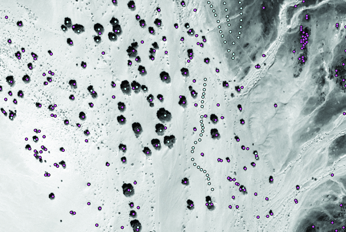
Image Caption
Vegetation classifier algorithms identify trees and shrubs in a section of Niger. In this image purple circles mark vegetation sites, and blue circles mark the original training data (including non-vegetation sites). Image: ©2012 DigitalGlobe, Inc., licensed under NextView.Jamon Van Den Hoek, Gerasimos Michalitsianos, John L. David, NASA/Goddard
Download High-Res Image
Contacts
Hoot Thompson, NASA Goddard Space Flight Centerjohn.h.thompson@nasa.gov Daniel Duffy, NASA Goddard Space Flight Center
daniel.q.duffy@nasa.gov