Modeling the World in High Resolution
A NASA climate model resolving Hurricane Sandy and weather phenomena on a global scale offers a captivating preview of future simulation capabilities.
In late October, Hurricane Sandy bore down on the U.S. East Coast with peak winds of 90 miles per hour and local rainfall in excess of 10 inches, causing extensive flooding and power outages. Before Sandy's arrival, anxious residents heard weather reports of multiple computer model predictions converging on storm tracks turning the hurricane westward for a direct hit. A NASA climate model simulating Sandy and other weather phenomena on a global scale offers a captivating preview of future weather and climate simulation capabilities.
The Goddard Earth Observing System Model, Version 5 (GEOS-5) typically uses grid boxes 25 kilometers (km) wide for five-day global forecasts that run every six hours on the Discover supercomputer at the NASA Center for Climate Simulation (NCCS). To closely focus on Sandy's treacherous winds, a NASA scientist more than tripled the atmospheric model's grid box resolution to 7 km for a seven-day simulation, beginning as Sandy passed the Bahamas on October 26.

"We can see the massive size of Sandy and how strong the onshore winds were in New York and New Jersey even after landfall and the dramatic influence of the land surface slowing down Sandy's inland surface winds," said William Putman, meteorologist in the Global Modeling and Assimilation Office (GMAO) at NASA Goddard Space Flight Center, Greenbelt, Md.
Applying high resolution to a longer time period, Putman used 3,750 processors of Discover to run GEOS-5 at 10 km for a full two simulation years. "This global mesoscale simulation gives us a dynamic view of weather within Earth's climate system," he said. "The model allows us to explore many aspects of regional weather and how these events vary with the changing climate around the world."
Putman's 10 km simulation covers the period May 2005 to April 2007, chosen to include the record-setting 2005 Atlantic hurricane season. "The climate within the model is guided by observed sea surface temperatures and aerosols, and then left to freely evolve the variations of weather within the evolving climate state," Putman said. This approach permits comparison of the simulated variability from GEOS-5 to real-world weather variability and supports a diverse range of research:
- Hurricanes — For the 2005 Atlantic season the model impressively spawned 23 hurricanes and tropical storms compared to 28 observed storms, captured sometimes rapidly changing storm intensities, and began to represent the strongest hurricanes with near-surface winds over 160 miles per hour.
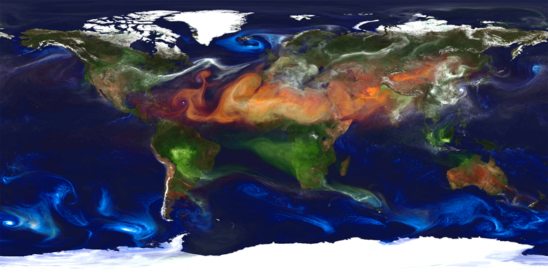
- Aerosols — Within the GEOS-5 simulation, strong winds carry tiny particles of dust, sea salt, sulfates, and organic and black carbon from their sources to distances across continents and oceans, where these aerosols can have a significant impact on air quality, visibility, and human health.
- Data experiments — NASA researchers can run observing system simulation experiments that involve assimilating data from current or planned (simulated) satellite instruments and then studying their effect on forecast accuracy, thereby helping NASA improve its observation suite and its data assimilation capability that processes millions of observations daily.
Putman also has run experimental versions of GEOS-5 at 3.5 km, further approaching the resolution of satellite instruments. Such "global cloud-resolving models" can simulate individual cloud microphysics and other fine-scale features. To complete a five-day forecast within NASA's three-hour operational window, this class of models requires more than 20 times the current capability of the NCCS Discover supercomputer. As NCCS substantially increases Discover's speed by incorporating new technologies such as Intel's Xeon Phi Many Integrated Core co-processors, the future potential of global atmospheric modeling is that much closer on the horizon.
Related SC12 Demo
Mesoscale
Mesoscale weather systems occur on scales as small as 5 kilometers. Mesoscale computer models generally cover up to a single continent for weather forecasting. For example, a leading North American model runs at 12-kilometer resolution. Models such as NASA's GEOS-5 are applying mesoscale resolution to the entire globe, with resolutions ranging from 3.5 to 10 kilometers.
Contact Information:
William M. Putman
Global Modeling and Assimilation Office
NASA Goddard Space Flight Center
william.m.putman@nasa.gov
(301) 286-2599
More Information:
"We can see the massive size of Sandy and how strong the onshore winds were in New York and New Jersey even after landfall and the dramatic influence of the land surface slowing down Sandy's inland surface winds." — William Putman, NASA Goddard Space Flight Center
